Best Sight Seeings:

Saturday, April 25, 2009

Bali "Largest Tourism Destination Of Indonesia"

Bali, un goût de paradis by =guitz=.

Bali is an Indonesian island located at the westernmost of the Lesser Sunda Islands, lying between Java to the west and Lombok to the east. It is one of the country's 33 provinces with the provincial capital at Denpasar towards the south of the island.
With a population recorded as 3,151,000 in 2005, the island is home to the vast majority of Indonesia's small Hindu minority. 93.18% of Bali's population adheres to Balinese Hinduism, while most of the remainder follow Islam. It is also the largest tourist destination in the country and is renowned for its highly developed arts, including dance, sculpture, painting, leather, metalworking and music.


Ubud


The centre of Balinese painting, Ubud's Museum "Purl Lukisan" has a permanent collection of modern works of Balinese art dating from the turn of the century. There are also several art galleries and homes of famous artists here, including that of Dutchborn Hans Snel and American Antonio Blanco. The "Young artist" style now popular in Balinese painting was introduced by the Dutch painter Arie Smith. In the past, other foreign painters inspired Balinese artists to adopt western techniques but traditional Balinese paintings are still made and sold another museum called "Neka Museum" has a wide collection of paintings both by Indonesian as well as foreign artists who used to live in Bali. Ubud has several small hotels. Located on a higher altitude with a pleasant climate.


Nusa Dua


The Nusa Dua tourist resort is part of the Bukit Peninsula in southern Bali. Some of the most beautiful and luxurious hotels are found here. The resort is known for its clean white beaches and clear waters. The surf is gentle along the northern side of the peninsula, bigger along the south. The most convenient form of transportation to and from Nusa Dua is by taxi.


Batubulan


Driving northeast from Denpasar, stone figures on the roadside mark the village of Batubulan. Divinities and demons are carved from sandstone for ornaments of houses and temples. Workshop can be visited to watch artists at work.


Pura Besakih


Known as the "mother Temple of Bali, the sanctuary of Besakih on the slopes of Mt. Agung is the biggest and holiest of all Balinese temples. Over a thousand years old, steps ascend through split gates to the main courtyard where the Trinity shrines are wrapped in cloth and decorated with flower offerings.Around the three main temples dedicated to the Trinity: Shiva, Brahma and Wisnu, are 18 separate sanctuaries belonging to different regencies and caste groups.To the Balinese, a visit to the temples sanctuaries is a special pilgrimage. Each has its own anniversary celebration or "Odalan". The sight of the temple against the background of the mountain is impressive and during festivals, coloured banners add a touch of gaiety.


Pura Kehen


Pura Kehen is the religious heart of Bangli's many temples. One of the largest religious complexes in Bali, its origins can be traced back to the beginning of the eleventh century. A huge banyan tree shades the first courtyard.


Kuta


Once a lonely village on the road from Denpasar toward the Bukit Peninsula, Kuta is now a thriving tourist resort, popular mainly among the young. It is a popular beach for surfing although currents make it less suitable for swimming. Coast guards, however, are on constant duty during the day. Kuta faces toward the west offering beautiful sunsets.Accommodation ranges from international hotels to home stays. The village abounds with restaurants, shops, discotheques and other tourist facilities. It is easier to find regular performances of Balinese music and dance in Kuta, staged specially for tourists, than anywhere else in Bali. Some performances are staged nightly. The village is ideal for meeting and mixing with other people, locals as well as visitors from abroad.


Tanah Lot


One of Bali's most important sea temples, the temple sanctuary at Tanah Lot is built atop a huge rock which is surrounded by the sea.Built by one of the last priests to come to Bali from Java in the 16th century, its rituals include the paying of homage to the guardian spirits of the sea. Poisonous sea snakes found at the base of the rocky island are believed to guard the temple from evil spirits and intruder.The best time to see Tanah Lot is in the late afternoon when the temple is in silhouette.


Gianyar


Once the capital of one of Bali's more powerful kingdoms, the town of Gianyar is today a centre of the textile industry. The specialty here is the ikat weaving the Balinese use in traditional wear. A number of factories hold informal tours.


Terraced rice paddies


Whether it is bright and sunny or rainy and gloomy, the trip through the landscape of terraced rice paddies between Candidasa and Amlapura is one of remarkable scenic beauty. Allow plenty of time for photo stops.


Gunung Batur


The still-active Gunung Batur volcano, at an altitude of 1,717 meters (5,635 ft), is revered by the Balinese as the sec-ond-holiest mountain on the island (after Gunung Agung) and symbolises the female element next to Agung's male.


Candi Dasa Beach


Candidasa is the name of a temple complex on a lagoon by the edge of the sea. Set at the foot of Mount Agung, the white sandy beach of the temple is only visible when the tide is out but the grassy foreshore and beach are great places to catch the sun. Started in the early 1980s this romantic area, also called Candidasa became the developing tourist destination, though it still offers an escape from the hassles of the more populated tourist areas. Candi Dasa is an excellent base for daytrips around Eastern Bali. Tenganan, Goa Lawah, Amlapura and Padangbai are all within easy reach. And good diving is available a little further afield at Tulamben, where a US ship sunk during World War-II and may be viewed in its underwater resting-place. You can also hire boats for a day's snorkeling. Diving equipment is available for rental at reasonable prices.


Kuta Beach


Once a lonely village on the road from Denpasar toward the Bukit Peninsula, Kuta is now a thriving tourist resort, popular mainly among the young. It is a popular beach for surfing although currents make it less suitable for swimming. Coast guards, however, are on constant duty during the day. Kuta faces toward the west offering beautiful sunsets. Accommodation ranges from international hotels to home stays. The village abounds with restaurants, shops, discotheques and other tourist facilities. It is easier to find regular performances of Balinese music and dance in Kuta, staged specially for tourists, than anywhere else in Bali. Some performances are staged nightly. The village is ideal for meeting and mixing with other people, locals as well as visitors from abroad.

Lovina Beach


A restful tourist area west of Singaraja on the northern coast. This area is relaxed and hassle-free. The beaches are of black volcanic sand and a reef keeps any surf at bay. Or you can diving and snorkeling in the mirror smooth seas, and the dolphins that often race with the tour boats. The beach area consists of several small villages that seem to start where the last one finished, although they are all spread quite thinly along the long beach strip. You can also make day trips to the hot springs of Banjar, the West Bali National Park, to temples and various craft centers.


Pantai Seseh


Start the beach walk of your life just south of Tanah Lot. Pantai Seseh is a quiet beach of black volcanic sand that is mainly visited by local fishermen. Quiet, rough, and close to nature, this beach is simply unforgettable.


Sanur Beach


With its white sand on the south and black sand on the north part, Sanur beach is a popular recreation site not far from Denpasar. Sanur is protected from the force of the ocean waves by a coral reef offshore, so the waves on the shore are rather small and gentle. This makes it an ideal place for a quiet family swim, wind surfing, boating and water sports. Its traditional culture is very strong, but it wears modern dress (except, of course, on ritual occasions). Among the Balinese, Sanur has a reputation for sorcery of a high degree, both "white" and "black". Sanur is famous for its white coral temples (Pura Segara, Pura Merta Sari). There are many small ones hidden away along the south beach. In December and January, watch the huge processions to the sea with purification ceremonies on the beach. There are often gamelan rehearsals in the evenings at the various banjar.

Sanur beach has long been a popular recreation site for people from Denpasar and elsewhere. The palm-lined beach curves from the Bali Beach Hotel toward the south, facing the Indian Ocean to wards the east. Sanur offers many good hotels, restaurants, shops and other tourist facilities. It is only a shot distance from Denpasar public transportation to and from the city are easily available until well into night. Offshore reefs protect the beach against the waves and make it popular for windsurfing, boating and other watersports.Tegal Besar BeachThere are further beautiful beaches in Bali besides those of Sanur and Kuta. One of these beaches is located in Klungkung regency near Banjarangkan village, known as Tegal Besar beach.Black sands are a particular characteristic to this beach. Because of its beauty and natural atmosphere, the beach lures visitors to come there. Several fishing boats stationed here add to the beauty of the panorama.Looking westward from the beach, another beach is visible. This is the Lebih village beach belonging to the regency of Gianyar, with Nusa Penida island to the south Klungkung’s beach is preparing to be developed into a tourist object.One of the forerunners is already renovating his restaurant there. Small stalls have been also prepared to serve customers. In the morning fishermen go out to sea to catch fish.


Transportation


BOAT & FERRY
The more than 13,600 islands of the Idonesian archipelago stretching over an area of 5,200 km into the Pacific ocean, present a plenty of choices to explore. Bali has three main ports:* Benoa in the south.* Padang Bai in the east.* Gilimanuk in the north west.Several major shipping lines make Padang Bai and Benoa ports of call on around the world cruises.If you would like to explore the islands near Bali you have a wide range of choices for boating expeditions with anything from a few hours in traditional jukung to day criuses or longer overnights trips on yachts or luxury cruisers.


PUBLIC TRANSPORT
The public transport system in Bali can virtually take you anywhere you want to go but slowly. By far the cheapest way to travel, although not the most comfortable.Buses, except the inter-island buses, and bemo’s (mini-vans) are often overcrowded and hot. There are recommended for short trips only. They do have the redeeming factor of being very cheap. Wait by the side of the road and one will inevitably pass by for you to flag down to stop. Get down where you want by loudly saying: "STOP!".Bemo’s generally cater for local traffic routes not tourist routes. Bu you can also charter empty bemo’s for a higher price.

BICYCLE
Cycling can be a cheap and enjoyable way to get around, although you do have to be quite fit to ride around the central, hilly regions, but you will be closer to the action.Bicycles are available but bear in mind the heavy traffic in Kuta, Legian, and Denpasar. Cycling is ideal in villages, Ubud and the countryside.You can find bike rental shops in all the main tourist spots.


MOTORBIKE
As with hire cars, you can find motorbikes for rent almost anywhere. A special permit available at police stations for renting a motorbike. The rental company can help you to obtain this.Like renting a car, you should always check the bike before parting with your cash.In Indonesia you have to wear a helmet by law.


CAR AND BUS
There are many models of transport to help you " jalan-jalan" your way around Bali. A varietyof excellent tour packages are available from your hotel desk or any of numerous travel agents and tour operators.Or you can find a car and driver who will also act as your guide.You can also find a car rental agency in all the major tourist areas. You will need your licence from your homecountry and an international driving licence for renting a car.Types of cars available are usually small jeeps or kijang ( a station car with capacity for 6-8 people). Although mostof the cars for rent are in decent shape, you should check thoroughly before signing any forms.Fammilies or groups can charter aprivate bus with driver. Many buses are airconditoned. Stopovers and side-trips can be planned and this is an ideal way to experienceBali at your own pace.

Some of advices if you drive:
Driving in Bali always expect the unexpected. Always keep your eyes and your mind open on driving.It is not unusual for cars and bikes to swerve into your lane without indication. Because there are often obstacles such as parked cars ofthe ever present procession of ‘bakso’ trolleys on the side of the road, a system of "sharing lanes" has developed.
Be aware that drivers from side streets often don’t look when joining a main road and the larger vehicle is king of the road.
Remember to "hoot" your horn when going around curves on mountainous roads as it is very common to drive in the middle of the road here.


TAXI
Metered taxis are readily available at very reasonable prices. There is a minimum charge of Rp. 4000flagfall and you can book by phone, with exception taxis from airport where the prices, depend on the destination, are fixed.If the driver is hesitant to put on the meter, insist or change taxi’s.

There are several taxicabs: Airport Taxi, Bali Taxi, Blue Bird Taxi, Pan Witrhi Taxi, Praja Taxi


AIR TRANSPORT
Several international airlines make regular flights to Ngurah Rai Airport Denpasar, and they include:

AN Ansett Australia

NZ Air New Zealand

BA British Airways

CX Cathay Pacific Airways

CI China Airline

CO Continental Micronesia

BR Eva AirGA Garuda Indonesia

JL Japan AirlinesKE Korean Air

MH Malaysian Airline System

QF Qantas Airways

BI Royal Brunai AirlinesS

K Scandinavian Airlines System

SQ Singapore Airlines

TG Thai Airways International


Several Indonesian airlines also make the daily flight to Denpasar.

They are:BO Bourag International

MZ Merpati Nusantara

SG Sempati Airline

Passengers departing from international and domestic flights will have to pay the airport tax. For international flights the tax amount to Rp. 25,000 while that for domestic flights is Rp. 11,000.Visitors to Indonesia are allowed to bring in tax-free a maximum of one litre of alcoholic beverages and 200 cigarettes or 50 cigars or 100 grams of tobacco.

Thursday, April 23, 2009

Yunnan "South of the Clouds"


Yunnan is a province of the People's Republic of China, located in the far southwest of the country spanning approximately 394,000 square kilometers (152,000 square miles). The capital of the province is Kunming. The province borders Myanmar (Burma), Laos, and Vietnam.
Yunnan is situated in a mountainous area, with high elevations in the northwest and low elevations in the southeast. Most of the population lives in the eastern part of the province. In the west, the relative height from mountain peaks to river valleys can be as much as 3,000 m. Yunnan is rich in natural resources and has the largest diversity of plant life in China.

Butterfly Spring

Travel some 27 kilometers south of Dali and you will come to a popular beauty spot known locally as the "Butterfly Spring". Situated at the foot of Mount Shenmo, the first of the peaks of Mount Cangshan the spring rises to form a square shaped pool that is shaded by the dense foliage that lines its banks. The pool is some 50 square meters overall and above it is an ancient decumbent tree. This is the famous "Butterfly Tree", so called as in the short interval as spring turns to summer, its fragrant blossom attracts thousands of butterflies. These small multi-colored creatures fly around the pool and settle on the tree in great clusters as they sip the nectar from its blooms. The vast numbers of butterflies are hardly distinguishable from the flowers as the whole tree pulsates with every color of the rainbow. This spectacular sight has given rise to a local festival when the Bai people gather at the tree on April 15th for the "Butterfly Meet". The romantic spectacle of the butterflies as they feed and mate in such abundance has become a symbol of courtship and each Bai youth will seek to engage with the love of his life by joining in with the traditional antiphonal singing. The Bai also refer to the spring as the "Allegiance Spring" as it is here that true and lasting love may be found.

Cangshan Mountain

Cangshan Mountain, two km west of Dali, form the backdrop for Dali City. Together with Erhai Lake, the imposing mountain range makes Dali a true vacation getaway. The stunningly beautiful mountainboasts high snow capped peaks, shifting clouds, and babbling streams. With an average height of 4000 m, it has a cluster of 19 soaring peaks. The highest peak, Malong, spires 4,122 m high. On Shengying peak, there is a huge chess board covering 460 square metres! Streams trickle down between every two peaks. With thick forest and vegetation, the mountain also boasts a botanical garden and a zoo.

Dry Sea

Dry Sea is a vast meadow with an altitude of 3,100 meters (10,171 feet). Just as its name implies, it had been a highland glacial lake before the 1940s and was formed after the water had dried up. Dry Sea is located at the east foot of Jade Dragon Snow Mountain and is only 25 kilometers (15.5 miles) away from Lijiang Old Town.
Surrounded on all three sides by the superb mountains, Dry Sea is the closest and also the best place to get a panorama of Jade Dragon Snow Mountain. The 13 peaks of Jade Dragon Snow Mountain are covered by the undefiled white snow wriggle from the north to the south, like a white jade dragon flying and playing leisurely in the sapphiric sky. The name of the highest peak, Shanzidou (Fan Peak) originates from its shape. From one angle of view, it looks like a gigantic unfolded fan cutting in the clouds.
On the heavily forested Dry Sea, spring is a busy season, for the meadow bursts into colorful blooms and is full of energy. In the sunny days of summer, fantastic green glittering glaciers can be seen clearly through the telescope. It is the flourishing plants all over the mountains that tinge the glaciers with the filmy green. When autumn comes and brings a gentle breeze that kisses the meadow turning the green leaves on the deciduous trees into bright yellow, orange, and scarlet. In winter, the pure snow covers this world making the meadow and the mountains show a kind of holy beauty. Dry Sea is an abundant pasture and views of local herders who intersperse their groups of grazing livestock (including the cattle, the goats, the sheep and the domesticated yaks) are easy to be seen.

Erhai Lake

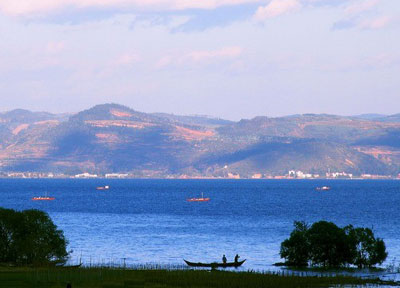
Erhai Lake is the largest highland lake next to Dianchi and one of the seven biggest fresh water lakes in China. It means, "sea shaped like an ear", in Chinese. Implying that the lake is ear shaped and as large as a sea, hence it was so named. The lake covers an area of 250 square kilometers and is located about two kilometers east of Dali. It is like a crescent lying between Cangshan and Dali city as seen from Cangshan Mount. In a sunny day, the crystal waters of Erhai Lake and the snow mantled Cangshan Mount radiate with each other. Thus the scene was commonly described as "Silver Cangshan and Jade Erhai".

Jade Dragon Snow Mountain

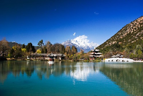
According to the geologists' research, for about 400 million years the area around Jade Dragon Snow Mountain was the ocean and it was during the last 600 thousand years that the different landscapes had come into being because of the uprising of the lithosphere. Archaic legend about this mysterious and beautiful snow mountain goes like this: Once upon a time, Jade Dragon Snow Mountain and Haba Snow Mountain were twins. They had lived on panning in Golden Sand River until one day an evil fiend usurped the river. The brothers were very brave and had a fierce fight with the fiend, Haba died in the fight and Jade Dragon drove off the fiend after wearing out 13 swords. For guarding the people and preventing the return of the fiend, Jade Dragon held the 13 swords in hands day and night. As time passed, the brothers had turned into the two snow mountains, and the 13 swords had become the 13 peaks. Jade Dragon Snow Mountain is a holy mountain for the local Naxi people not only because of the legend, but also because long time ago, it was a place for young lovers to sacrifice their young lives in honor of true love and to escape from the arranged marriages and feudal ethics.

Lijiang Old Town

As a result of the combination of the multinational culture and the progress of Naxi ethnic minority, the buildings in the town incorporate the best parts of the architectural traits of Han, Bai, and Tibet into a unique Naxi style. The layout of the town is free-style and flexible, the houses are close and diverse, and the lanes are narrow and meandering. Naxi people pay much attention to the decoration, the commodious and applied houses are mostly timber and tile structure compound with a garden, each has engraved vivid figures of people and animals on doors and windows, beautiful flowers and trees in the garden.Living in such a beautiful and comfortable environment is a real pleasant thing.
The center of the Old Town is the Square Street (Sifangjie). Four main streets radiate from Square Street and extend to the four different directions. Countless lanes extending in all directions form a network and connect every corner of the town. Streets in the Old Town are paved by the local bluestones which are neither muddy in the rainy season nor dusty in the dry season. The massive and fine-grained stones add a sense of antiquity and mystery to the Old Town. The sluice at the center of town is opened late in the night and the resulting current of water flushes and washes all the streets to keep the town clean. This practical use of water is part of the daily life of the residents in Old Town.

Lugu Lake

Lugu Lake is long and narrow, like a hoof filled with limpid water. Five small forested islands are interspersed across the surface, three of which are in Yunnan precinct. The smallest island is called Lige Island, and there are only eight Mosuo families living on it. Another island, called Chieftain Island, was named because Ayunshan, the chieftain of Yongning Village, had built a villa and lived here until his death in the Guangxu period of the Qing Dynasty. Simultaneously, Joseph Rock, an Austrian writer who was his friend, wrote part of the Ancient Nakhi Kingdom of South-west China (Harvard University Press, 1947) on this island. Liwubi Island, which lies three kilometers (one point nine miles) away from Chieftain Island, is actually a small peninsula extended into the lake by the Holy Gemu Mountain. The mountain is also called Lion Mountain, for it looks like a lion drinking water beside the lake. Mosuo people believe that a beautiful and kind goddess named Gemu lives on the mountain and blesses the residents at all times. A great sacrificial rite is held to worship the goddess on July 25th of each lunar year at the foot of Gemu Mountain.

Stone Forest

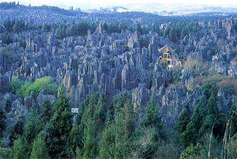
The Stone Forest is in Lunan Yi Nationality Autonomous County, which is about 120 kilometers (75 miles) from Kunming and requires only a three-hour drive. It covers an area of 400 square kilometers (96,000 acres) and includes both large and small stone forests, as well as many other scenic spots. An old local saying says that "If you have visited Kunming without seeing the Stone Forest, you have wasted your time." Truly, the Stone Forest is one of the most important attractions of Yunnan.
Walking through the Stone Forest, visitors marvel at the natural stone masterpieces and are bewitched by the intricate formations. The magnificent, strange and steep landscape creates countless labyrinthine vistas, including:
Stone Forest , all of which feature stones in various formations. Animals, plants, and even human figures can be found here. Some are elegant, some are rugged, and each is lifelike with its own distinguishing characteristics.


SubteStone Forest rranean Stone Forest in Zhiyun Cave, an underground stone forest distributed among several caves and occupying a total area of about three square kilometers (720 acres).
Strange Wind Cave, composed of Penfeng Cave, Hongxi Spring and an underground river. From August to November, gales lasting two to three minutes sweep out of the cave every 30 minutes.
Long Lake is a karsts lake that is three kilometers (two miles) long but only 300 meters (zero point two miles) wide. The lake features underwater stalagmites and stalactites and a small island in the center of the water.
The source of the Dadie Waterfall, Ba River, is a branch of Nanpan River. In the rainy season, up to 150 cubic meters (196 cubic yards) of water per square inch plummet down the 88 meter (288 feet) drop.

Tiger Leaping Gorge

About 100 kilometers (62 miles) northwest of Lijiang Old Town lying between Jade Dragon Snow Mountain (Yulong Xueshan) and Haba Snow Mountain (Haba Xueshan) is Tiger Leaping Gorge (Hutiao Gorge), which is believed to be the deepest gorge in the world. From the top of the gorge you look down the steeply angled (70-90 degrees) mountain sides to the rushing Golden Sands (Jingsha) River with its 18 frothing rapids more than 200 meters (about 700 feet) below.
Naturally divided into three sections, the first section, which is the narrowest and uppermost section, is the mouth of the fast flowing Jingsha River. In the midst of the river's mouth is a large rock that is positioned at the gorge's narrowest section-only 30 meters (33 yards) wide. An ancient legend says that a tiger used this rock as its stepping stone so it could leap across from one side of the gorge to the other, which is how the gorge got its name.
As the river enters the middle section, it drops another 100 meters (330 feet) and its flow rate increases to an amazing speed. Here the thunderous rushing waters slam into sharp, large rocks and crash down into the river forming swirling whirlpools. Can it get more exciting? Yes, it can as the third and lowest section is acclaimed for being the wildest attraction of all!

Meili Snow Mountain

Meili Snow Mountain, also called "Prince Snow Mountain," is located about 10km west of Deqing city in Diqing prefecture, at the confluence of the Jinsha, Lancang and Nu rivers.
In this area, strong updrafts meet with continental cold air masses, forming thick fog and heavy snow. Yet due to vertical climate differences, Meili Mountain also features abundant blooming azaleas and verdant trees, which contrast with the snow-capped peaks, creating a charming scene here.
Meili Snow Mountain has long been famous for its main peak, Kagebo Peak, which, at an elevation of 6,470 meters (21,221 feet) above sea level, is the tallest in Yunnan.
Surrounded by 13 lesser peaks, which are the subject of an enchanting tale, Kagebo Peak is extolled as the "most beautiful mountain in the world." On the southern side of the main peak, a waterfall - known among the local people as "a deluge of rain and God-mandated cascade" - tumbles down from a breathtaking height of 1,000 meters (3,280 feet).
Under Kagebo Peak, low-altitude modern glaciers can be found, which are of particular interest to those engaged in geological research. Mingyongqia Glacier and Siqia Glacier stretch down to the forest at an elevation of 2,700 meters (8856 feet), only 800 meters (2624 feet) from the surface of Lancang River. It is an eternal modern monsoon maritime glacier with low latitude and high altitude.

Three Pagodas

Many sculptures of Buddha made of gold, silver, wood or crystal, Buddhist readings, and more than 600 various medicinal ingredients were found in Qianxun Pagoda, playing an important role in explaining the ancient history of Dali City. Study of Three Pagodas and the cultural relics that have been excavated at the site provide significant data for exploring the history, religion, and art of the area. Today, travelers can visit Three Pagodas at night, when it is illuminated providing a fantastic scene. Nearby on the 'marble street' there are many folk-craft workshops and stands specializing in marble and brick-painting.
Known for its resilience, Three Pagodas has survived several eras of severe earthquakes. The local government still makes a great effort to strengthen it to make it as strong as when it was built to ensure the preservation of this architectural treasure.

Transportations
Railways
Yunnan was first connected by railway not to the rest of China, but to the Vietnamese port of Haiphong by a French engineered narrow gauge railway, the Sino-Vietnamese Railway completed in 1910. It took another fifty years for the province to be connected by rail to the rest of China with the completion of the Chengdu-Kunming line. Later a line connecting Kunming to Guiyang followed. Two further lines have been added recently: a southern line connecting to Nanning and a north-eastern line connecting to Sichuan via Yibin.
An extension now also links Kunming to Dali, with the stretch to Lijiang nearing completion. Plans are underway on extending the old line to Vietnam, while a new and very ambitious plan to link from Dali to Ruili has been announced in 2006. Another plan to extend the railway line from Kunming all the way to Singapore, with connections to the other South East Asian countries, will be opened in 2017.
Road and railroad traffic has been recently improved, and Kunming is now a transportation center; an important railroad runs from Kunming to Hanoi, Vietnam, while transportation to Myanmar is maintained by the Burma Road.

Burma Road
The Burma Road was a highway extending about 1,126 km (700 mi) through mountainous terrain from Lashio, northeast Burma northeastward to Kunming, China. Undertaken by the Chinese after the start of the Sino-Japanese War in 1937 and completed in 1938, it was a vital transportation route for wartime supplies to the Chinese government from Rangoon and shipped by railroad to Lashio from 1938 to 1946. An extension runs east through China from Kunming, then north to Chongqing. This traffic increased in importance to China after the Japanese took effective control of the Chinese coast and of Indochina. It was seized by the Japanese in 1942 and reopened when it was connected to the Stilwell Road from India. The Ledo Road (later called the Stilwell Road) from Ledo, India, into Myanmar was begun in December 1942. In 1944 the Ledo Road reached Myitkyina and was joined to the Burma Road. Both roads have lost their former importance and are in a state of disrepair. The Burma Road's importance diminished after World War II, but it has remained a link in a 3,400-km road system from Yangon, Myanmar, to Chongqing.

Highways
Road construction in Yunnan continues unabated: over the last years the province has added more new roads than any other province. Today expressways link Kunming through Dali to Baoshan, Kunming to Mojiang (on the way to Jinghong), Kunming to Qujing, Kunming to Shilin (Stone Forest). The official plan is to connect all major towns and neighbouring capitals with expressways by 2010, and to complete a high-speed road network by 2020.
All county towns are now accessible by paved, all-weather roads from Kunming, all townships have a road connection (the last to be connected was Yangla, in the far north, but Dulongjiang remains cut off for about six months every year), and about half of all villages have road access.
Second-level national highways stretch 958 km, third-level highways, 7,571 km and fourth-level highways, 52,248 km. The province has formed a network of communication lines radiating from Kunming to Sichuan and Guizhou provinces and Guangxi and Tibet autonomous regions, and further on to Myanmar, Laos, Vietnam and Thailand.

Luofu Expressway
After the opening of the Suolongsi to Pingyuanjie expressway, Luofu expressway, the first between Yunnan and Guangxi Province, opened on October 2007. It has made material and passenger transportation between the two provinces much more convenient. Moreover, Luofu Expressway has also become the main road from Yunnan to Guangxi and the coastal ports. Luofu Expressway begins from the crossroads of Luo Village between Yunnan and Guangxi Provinces and ends at Funing County of Wenshan State. The total length of the expressway is 79.3 kilometers which has shortened the commute between Yunnan and Guangxi from the previous 3 and half hours to just 50 minutes.

Waterways
Generally, rivers are obstacles to transport in Yunnan. Only very small parts of Yunnan's river systems are navigable. However, China is constructing a series of dams on the Mekong to develop it as a waterway and source of power; the first was completed at Manwan in 1993.
In 1995, the province put an investment of 171 million yuan to add another 807 km of navigation lines. It built two wharfs with an annual handling capacity of 300,000 to 400,000 tons each and four wharfs with an annual handling capacity of 100,000 tons each. The annual volume of goods transported was two million tons and that of passengers transported, two million.

Airports
The Wujiaba Airport in Kunming is a national first-class airport and the other airports are second-class terminals. A new airport for Kunming, build east of the city, at Dabanqiao began construction in 2006, but is not expected to be completed until 2015.

Wednesday, April 22, 2009

Amsterdam "Red Light District and Marijuana"

Amsterdam, Herengracht, spring by docman.

Lively, lascivious Amsterdam has a unique atmosphere that belies the caricature of the dour Dutch.Radiating out from the Dam Square, the historic centre of the city is ringed by quaint canals and cobbled streets, thronged with bicycles, tourists, houseboats, students, and street performers. The city wears two faces: on one it smiles and beckons hedonistic youth with its notorious Red Light District and liberal view of marijuana use, while on the other it offers some of Europe's finest museums and art galleries.For the tourist the joy of Amsterdam is its compactness. The old part of town is a pleasure to explore on foot, strolling across ancient bridges and down narrow lanes past gabled houses, dropping in to browse in inviting souvenir boutiques crammed with blue and white Delft china and wooden clogs. Pavement cafes and cosy bars offer rest and refreshment. An alternative is to take a circular canal-boat cruise and see the city from the water, peering in on the lives of the locals who live on houseboats lining the waterways.At night even the most conservative visitor is drawn by the lively atmosphere of the infamous Red Light District, known as De Wallen, which is bounded by the Oudezijds Voorburgwal and Oudeziujds Achterburgwal canals near the Dam Square. Here prostitutes display their charms in brightly lit shop windows and touts encourage passers-by to view raunchy floorshows. The best nightclubs, bars, and the theatres and cinemas are mainly to be found in the bustling Leidesplein and Rembrandtplein.

Anne Frank House

This museum is dedicated to the memory of Anne Frank whose famous diary, recorded over a two-year period, describes the experiences of a Jewish teenager during World War II. Part of the house was used as a hiding place by the Franks and others to escape Nazi persecution. The families were later discovered and sent to their deaths in the concentration camps. Otto Frank was the only survivor. The original diary is on display as part of the permanent exhibition. The museum also hosts temporary exhibits that focus on related issues.

Van Gogh Museum

The Van Gogh Museum is a definitive attraction in Amsterdam. Situated in a modern building, the simple architecture subtly underscores the artists' colourful and extraordinary work. The museum houses a permanent display of several hundred of Van Gogh's paintings and drawings, many of which will be familiar even to the untrained eye. The collection is organised according to three criteria. The first of these is the work of the artist, which is divided into five notable periods. Then there is the display of work of other artists including those of his friends and contemporaries. The third section is the showcase of the museum's history recording its progress with a feature on the development of the new wing designed by Japanese architect, Kisho Kurokawa, built to house the temporary exhibitions.

Red Light District (De Wallen)

A visit to Amsterdam would not be complete without a stroll around the notorious Red Light District. The atmosphere can be chaotic with throngs of tourists jostling for space alongside city slickers, pimps and drug dealers. The prostitutes of De Wallen are part of a legal and regulated industry that includes compulsory health checks and taxable income. Prostitution is by no means the only attraction of the area. The district's architecture comprises a scenic mix that dates back to the Middle Ages. Areas to explore include Waterlooplein, Zeedijk and Nieuwmarkt Square. Waterlooplein is the location of the modern City Hall and Muziek Theatre. The square was created in 1880 from two canals that were filled and then allocated to Jewish traders who used to ply their wares on its pavements. Nieuwmarkt Square was also once home to a thriving Jewish community, mainly Portuguese Jews who had fled from persecution during the Spanish Inquisition. The cultural diversity of this area extends to Zeedijk Street, which is often referred to as Chinatown. The street runs from the Saint Olof Chapel to De Waag.

The Royal Palace (Koninklijk Paleis)

Amsterdam - Koninklijk Paleis (Royal Palace) by jndotcom.

Although the Royal Palace is the official Royal residence it is mainly used for functions as the family reside in The Hague. The building dates back to 1648 and was originally designed for use as Amsterdam's city hall. King Louis Napoleon however had other plans. In 1808 he turned the city hall into a palace. A large collection of furniture from this period adorns its interiors. Guided tours are offered to visitors (these need to be booked two weeks in advance). The Royal Palace will be closed for renovations from 8 September 2005 until early 2009.

National Maritime Museum

East Indiaman Amsterdam m.mcholm-amsterdam_holland-29 by Mike McHolm.

Covering four centuries of Dutch naval history, the National Maritime Museum allows visitors to glimpse into the adventurous seafaring past of Dutch explorers and merchants through exhibits of antiquarian maps, navigation instruments, paintings and ship models, creating one of the most extensive collections of maritime memorabilia in the world. A major attraction is the life-size reconstruction of a Dutch East India Company ship called the Amsterdam, which is docked behind the museum. Learn about dated maritime trade, naval combat, fishing and whaling and the intrepid journeys that took the Dutch fleet and her crew to remote destinations as far away as modern day Indonesia, India and South Africa. Please Note: The National Maritime Museum Amsterdam will be closed until 2010 for major renovations. The Dutch East Indiaman Amsterdam is currently moored at the NEMO Science Centre where it is open to the public.

Amsterdam Coffee Shops

The Grasshopper, an Amsterdam coffeeshop by AndyH74.

Amsterdam's coffee shops are an iconic part of the city and for many tourists they constitute a unique and essential part of any visit to the Netherlands.In Amsterdam, 'coffee shop' means a place where cannabis is openly sold and smoked, while 'café' refers to somewhere that sells coffees, tea and cakes. The coffee shops can legally sell up to 5 grams of marijuana to adults over 18 years of age. Travellers are warned, however, that the personal possession of drugs is illegal.There are a variety of coffee shops in the city, from laid-back and mellow to psychedelic and loud. It is expected of customers to consume not only the cannabis but also a beverage or snack while at the venue. Most coffee shops offer several kinds of weed or hash, listed on a 'menu', which the staff can give advice on. The prices vary according to the quality and be warned: the local skunk is very strong!


Maastricht

Maastricht by JCJones.

Maastricht is the oldest city in the Netherlands, peacefully perching on the banks of the Maas River. It is also one of the sunnier spots, located at Holland's southernmost point, squeezed in between the Belgium and German borders. Ancient fortifications provide pleasant walking routes and some of these can be explored on the city's western outskirts. The Bonnefantenmuseum traces the city's historical roots, and makes for a good introduction to one's visit. Another must-see is the Basilica of Saint Servatius. It is a medieval cruciform basilica with a significant collection of religious artefacts as well as the burial place of Holland's first bishop. In the old centre of Maastricht is a selection of shops and department stores. Here one can also savour the fine food that Maastricht has developed a reputation for. A selection of wines from nearby vineyards can be savoured with the cuisine that has been influenced by the distinctive tastes of its neighbours. Maastricht is located 133 miles (215km) from Amsterdam.


Waterland Neeltje Jans


Enjoy a whole day with marine animals, experience fantastic attractions and see and learn about the world famous Delta Works at this spectacular water park. Attractions include the storm surge barrier, Delta Expo, a waterslide and water playground, whale world exhibition and a hurricane simulator.

Transportations

Amsterdam is one of the most bicycle-friendly cities in the world and is a centre of bicycle culture with good facilities for cyclists such as bike paths and bike racks, which pervade the city. In 2006, there were about 465,000 bicycles in Amsterdam. Theft is widespread - in 2005, about 54,000 bicycles were stolen in Amsterdam. Bicycles are used by all socio-economic groups due to their convenience, Amsterdam's small size, the large number of bike paths, the flat terrain, and the arguable inconvenience of driving an automobile. A wide variety of bicycles are used, such as road bicycles, mountain bikes, racing bikes and even recumbent bikes, but the vast majority of bicycles are second-hand, older-model, heavy bikes with no gears and back-pedal brakes. Bicycle traffic, and traffic in general, is relatively safe - in 2007, Amsterdam had a total of 18 traffic deaths, compared with 26 people murdered.
In the city centre, driving a car is discouraged. Parking fees are expensive, and many streets are closed to cars or are one-way. The local government sponsors carsharing and carpooling initiatives such as Autodelen and Meerijden.nu.
Public transport in Amsterdam mainly consists of bus and tram lines, operated by Gemeentelijk Vervoerbedrijf, Connexxion and Arriva. Currently, there are 16 different tramlines and a freight tram operation is being developed. There are currently four metro lines, with a fifth line, the North/South line, under construction. Three free ferries carry pedestrians and cyclists across the IJ to Amsterdam-Noord, and two-fare charging ferries run east and west along the harbour. There are also water taxis, a water bus, a boat sharing operation, electric rental boats (Boaty) and canal cruises, that transport people along Amsterdam's waterways. Approximately 35% of all people travelling in Amsterdam uses public transport.
The A10 Ringroad surrounding the city connects Amsterdam with the Dutch national network of freeways. Interchanges on the A10 allow cars to enter the city by transferring to one of the eighteen city roads, numbered S101 through to S118. These city roads are regional roads without grade separation, and sometimes without a central reservation. Most are accessible by cyclists. The S100 Centrumring is a smaller ringroad circumnavigating the city's centre.

A tram crossing a bridge over the river Amstel
Amsterdam was intended in 1932 to be the hub, a kind of Kilometre Zero, of the highway system of the Netherlands, with freeways numbered one through eight planned to originate from the city. The outbreak of the Second World War and shifting priorities led to the current situation, where only roads A1, A2, and A4 originate from Amsterdam according to the original plan. The A3 road to Rotterdam was cancelled in 1970 in order to conserve the Groene Hart. Road A8, leading north to Zaandam and the A10 Ringroad were opened between 1968 and 1974. Besides the A1, A2, A4 and A8, several freeways, such as the A7 and A6, carry traffic mainly bound for Amsterdam.
Amsterdam is served by nine stations of the Nederlandse Spoorwegen (Dutch Railways). Five are intercity stops: Sloterdijk, Zuid, Amstel, Bijlmer ArenA and Amsterdam Centraal. The stations for local services are: Lelylaan, RAI, Holendrecht and Muiderpoort. Amsterdam Centraal is also an international train station. From the station there are regular services to destinations such as Austria, Belarus, Belgium, the Czech Republic, Denmark, France, Germany, Hungary, Poland, Russia and Switzerland. Among these trains are international trains of the Nederlandse Spoorwegen and the Thalys, CityNightLine, and InterCityExpress.
Eurolines has coaches from Amsterdam to destinations all over Europe.
Amsterdam Airport Schiphol is less than 20 minutes by train from Amsterdam Central Station. It is the biggest airport in the Netherlands, the fifth largest in Europe, and the twelfth largest in the world in terms of passengers. It handles about 46 million passengers a year and is the home base of three airlines, KLM, transavia.com and Martinair. Schiphol was, in 2006, the third busiest airport in the world measured by international passengers.

Saturday, April 18, 2009

Cancun "Mexican Caribbean"


Cancún, on the Yucatán Peninsula. Cancun is located on the Yucatan Channel that separates Mexico from the island of Cuba in the Greater Antilles. The Cancun region is sometimes known as the Mexican Caribbean.
Cancun is the municipal seat of the Benito Juárez municipality and a world-renowned tourist resort. The city centre is located on the mainland which connects the Nichupté and Bojórquez lagoons to a narrow "7" shaped island where the modern beachfront hotels are located. The island of Isla Mujeres is located off the coast and is accessible by boat from Puerto Juarez.

Isla Mujeres Turtle Farm

Several species of sea turtle lay eggs in the sand along the island's calm western shore. Although they are officially an endangered species, sea turtles are still killed throughout Latin America for their eggs and meat, which are considered a delicacy. In the 1980s efforts by a local fisherman led to the founding of Isla Mujeres Tortugranja, which protects the turtles' breeding grounds and places wire cages around their eggs to protect against predators.
Hatchlings live in three large pools for up to a year, at which time they are tagged for monitoring and released. Because most turtles in the wild die within their first few months, the practice of guarding them until they are a year old greatly increases their chances of survival. The Turtle Farm is a scientific facility, not an amusement centre. But if you'd like to see several hundred sea turtles, ranging in weight from 150g (5oz) to more than 300kg (661lb), this is the place for you.


Mayan Temple


Dedicated chiefly to Ixchel, Maya goddess of the moon and fertility, this temple was 'discovered' by Francisco Hernández de Córdoba's expedition in 1517. The conquistadors found various clay female figures here; whether they were all likenesses of Ixchel or instead represented several goddesses is unclear. In 1988, Hurricane Gilbert almost completely destroyed the ruins.

Park Las Palapas

Park Las Palapas is quiet and safe, a great place for an afternoon picnic or an evening stroll.

Playa Delfines

Delfines is about the only beach with a public car park; unfortunately, its sand is coarser and darker than the exquisite fine sand of the more northerly beaches. On the upside, the beach has great views, there are some nearby Maya Ruins to check out and, as the last beach along the boulevard, it is rarely crowded. Heed the signs regarding swimming conditions as undertows are common here.

Playa Langosta

In the middle of the north end of Zona Hotelera, Playa Langosta is a gem of a place for swimming. Facing Bahía de Mujeres, the beach is coated with Cancún's signature powdered coral sand and the waters are quite shallow, making it good for snorkeling. If you've had enough of the water there are lots of beach restaurants and bars.

Plaza Las Américas

Plaza Las Américas at the south edge of the centro, is a vast modern shopping mall that includes the Liverpool and Chedraui department stores, a multiplex cinema, a food court and a salsa dance club. Don't confuse it with Plaza América, a small, aging arcade on Avenida Cobá with a few airline offices.

Puerto Juárez

Puerto Juárez is the main port for passenger ferries to Isla Mujeres. Punta Sam, the dock for the slower car ferries to Isla Mujeres, is about 7km north of downtown. Irregular services leave from the Zona Hotelera.

Yamil Lu'um

There are two sets of Maya ruins in the Zona Hotelera. The smaller site is Yamil Lu'um, where only the outward-sloping remains of the weathered temple's walls still stand; however, the ruin is still worth a visit, as much for its lovely setting as anything else.
To reach the site visitors must pass through either of the hotels flanking it or approach it from the beach - there is no direct access from the boulevard.
The tiny Maya structure and chac-mool statue on the beautifully kept grounds of the Sheraton Hotel are authentic and were found on the spot.

Zona Arqueológica El Rey

There are two sets of Maya ruins in the Zona Hotelera and, though neither is particularly impressive, both are worth a look if time permits. The first is the Zona Arqueológica El Rey, on the west side of Blvd Kukulcán between Km 17 and Km 18, there's a small temple and several ceremonial platforms. The other, much smaller, site is Yamil Lu'um.

Transportation
Bus, Local
PRICE 6 pesos (about 60 us cents)
Bus stops are marked "Parada" and show a picture of a bus. All busses marked "Hoteles R1" go on a circle route from the Hotel Zone and along Av. Tulum to the Crucero. Those marked R2 or R15 go to Wal-Mart. All other busses are a complete mystery that will not be solved by vacationing gringos. Service is quite frequent. During the evening rush hours, crowded busses will sometimes pass without stopping, often because they are on special contract transporting workers for some hotel or construction company.

Bus, out-of-town
The best way to go on day trips outside of Cancun as far as Tulum or Chichén-Itzá is to take one of the busses that leave from the central bus station downtown near the second traffic circle. Just try your best to understand the system, as we never quite got the gist of it in some two years of commuting from Puerto Morelos to Cancun. You buy your ticket at either of the two sets of windows representing the different lines.
The difference between first and second class busses is not immediately distinguishable, except there is reserved seating on first class long distance routes. Get to the bus station as early as possible in the morning and make sure that you know what time the last bus in the return direction leaves.
There is also luxury bus service to and from Mérida that is well worth the extra charge and is actually more convenient than going by air. Consult any travel agent.

Taxis
We defy death here to tell the truth about the taxi situation in Cancun. That is the exact and literal truth and may God strike us down with a thunderbolt if we lie. An informed source told us that the publisher of a leading tourist guide here was threatened with death for printing the official prices of taxi service in Cancun. Each taxi driver feels free to set his own rates, which are determined by secret consensus. You're supposed to know when the price has changed, even if it hasn't.

Wednesday, April 15, 2009

Lhasa "Highest Capital on earth"


Lhasa, sometimes spelled Lasa, is the administrative capital of the Tibet Autonomous Region in the People's Republic of China. Lhasa is located at the foot of Mount Gephel.
Traditionally, the city is the seat of the Dalai Lama and the capital of Tibet, and is one of the highest capitals in the world. It is the location of the Potala and Norbulingka palaces (both are included as World Heritage Sites), and in Tibetan Buddhism is regarded as the holiest centre in Tibet. The city is home to 257,400 people as of the 2004 census estimate.
Lhasa literally means "place of the gods", although ancient Tibetan documents and inscriptions demonstrate that the place was called Rasa, which means "goat's place", until the early 7th century.


Barkhor Street


For tourists, Barkhor Street is a magical place showing the original outlook of Lhasa. The street was paved by hand-polished stone boards. Though it is not broad, it accommodates thousands of tourists every day. Varied shops stand on both sides of the street and thousands of floating stands are on every corner. Most of them offer the prayer wheels, long-sleeve 'chuba' (the Tibetan people's traditional clothes), Tibetan knives and some religious articles for sale. Furthermore, some shops sell 'Thangka' (the Tibetan scroll painting), which is a unique art of Tibet with the themes of religion, history, literature, science and customs. Surprisingly, there are some articles from India and Nepal in this street as well.
To sum up, Barkhor Street is a place full of religious atmosphere and a world of exotic articles. If you have been attracted by it, you should go there. Believe your eyes, and you will get a lot of surprise there.

Jokhang Temple


The Jokhang Temple is a four-storey timber complex with a golden top. It adopted the architectural styles of the Tang Dynasty, as well as those of Tibet and Nepal.
Standing in the square of the Jokhang Temple, one can view the entire complex. On the square there are two steles, one recording an alliance between the king of Tibet and the emperor of the Tang, the other portraying the teaching of the Tibetan people to prevent and treat smallpox, a once incurable disease in Tibet.
In the eastern section of the yard there are rows of votive lights. These flicking lights provide a path leading all the way to the main hall. The main hall, over 1,300 years old, is the oldest shrine of the complex. Above the major entrance, there is a Dharma Wheel (chakra) flanked by two deer. This represents the unity of all things and symbolizes Sakyamuni himself. On both sides of the passageway, paintings showing the building of the temple, and renderings of the temple from the seventh century are adorned on the wall. The statue of Sakyamuni at age 12 sits in the middle of the hall. It has been gilded many times and decorated elaborately with jewels typical of Tibet. Statues of King Songtsem Gampo, Princess Wen Cheng and Princess Bhrikuti are on the second floor. On the top floor, there are four gilded bronze tile tops crafted in the emblematical Tang style.

Potala Palace


Originally built by King Songtsen Gampo in the seventh century, Potala Palace is located on the Red Hill of Lhasa, Tibet. Destroyed by lightning and war, Potala Palace had been rebuilt by the Fifth Dalai Lama in 1645. Since then, Potala Palace has become the seat of Dalai Lamas and also the political center of Tibet. The thirteenth Dalai Lama extended it to the present size, 117 meters (384 ft) in height and 360 meters (1,180 ft) in width, covering an area of more than 130, 000 sq meters (about 32 acres). Mainly comprised by the White Palace (administerial building) and the Red Palace (religious building), Potala Palace is famous for its grand buildings, complicated constructions, devotional atmosphere and splendid artworks.

White Palace


Upon entering the East Portal, visitors will come into the Deyang Shar courtyard where Dalai Lamas watched Tibetan opera. West of the courtyard is the White Palace. As the winter palace of Dalai Lamas, the White Palace is a seven-floor building originally built in 1645. The wall of the palace was painted to white to convey peace and quiet. The Great East Hall on the fourth floor is the largest hall in White Palace, occupying a space of 717 sq meters (about 7,718 sq ft). This hall was also the site for holding momentous religious and political events. The living quarters and offices of regents are on the fifth and sixth floors and while the top floor consists of the East Chamber of Sunshine and the West Chamber of Sunshine. Because of the sunshine in the chambers all year round, the East and West Chamber were the places where Dalai Lamas lived, worked and studied. The furnishings are sumptuousness and comfortable, revealing the dignity of Dalai Lamas. Standing on the spacious balcony, visitors can look down on beautiful Lhasa.

Drepung Monastery


Drepung Monastery (wylie: 'bras spungs dgon ), (literally “Rice Heap” monastery), located at the foot of Mount Gephel, is one of the "great three" Gelukpa university monasteries of Tibet.
The other two are Ganden and Sera. Drepung is the largest of all Tibetan monasteries, and indeed at its peak was the largest monastery of any religion in the world. It was founded in 1416 by Jamyang Chojey, a direct disciple of Je Tsongkhapa, the founder of the Gelukpa school. It is located on the Gambo Utse mountain, 5 kilometers from the western suburb of Lhasa.
Freddie Spencer Chapman reported, after his 1936-37 trip to Tibet, that Drepung was at that time the largest monastery in the world, and housed 7,700 monks, "but sometimes as many as 10,000 monks."


Norbulingka


Norbulingka literally: ( "The Jewelled Park") is a palace and surrounding park in Lhasa, Tibet which served as the traditional summer residence of the successive Dalai Lamas from the 1780s up until the PRC takeover in the late 1950s.
The park was begun by the 7th Dalai Lama beginning in 1755. The Norbulingka Park and Summer Palace were completed in 1783 under Jampel Gyatso, the Eight Dalai Lama, on the outskirts of Lhasa. and became the summer residence during the reign of the Eighth Dalai Lama.
The earliest building is the Gesang Pozhang Palace built by the 7th Dalai Lama. The 'New Palace' was begun in 1954 by the present Dalai Lama and completed in 1956. It contains chapels, gardens, fountains and pools. To the west the Kalsang Potang built by Seventh Dalai Lama is "a beautiful example of Yellow Hat architecture. Its fully restored throne room is also of interest."

Transportation
Railway
The Sichuan-Tibet Highway (G318) terminates in Lhasa starting in Chengdu.
Journalists report that the opening of the Railway—the highest plateau railway in the world—in July 2006 has brought with it an increasing demand for property which has pushed prices up.
Five trains arrive at and depart from Lhasa railway station each day. Train numbered T27 takes 47 hours, 28 minutes from Beijing West, arrives in Lhasa at 20:58 every day. The ticket costs 389 yuan for 'hard seat', or 813 yuan for a lower 'hard sleeper', 1262 yuan for a lower 'soft sleeper'. T28 from Lhasa to Beijing West departs at 08:00 and arrives in Beijing at 08:00 on the third day, taking 48 hours. There are also trains from Chengdu, Chongqing, Lanzhou, Xining, Guangzhou, and Shanghai. Initially the large altitude difference has caused problems on this route, giving passengers altitude sickness. To counter this, extra oxygen is pumped in through the ventilation system, and personal oxygen masks are available.
See also: Qingzang Railway and Lhasa railway station

Air
Lhasa Gonggar Airport is located about 98 kilometres south of the city. There is also a carpet factory there known for its high quality carpets, and the flagship hotel, the Lhasa Hotel has grown up in recent years

Google It:

Custom Search